The Ginger Jar Site – BRD 152
A very dense cluster of pottery sherds and fragments was discovered and recorded during the survey in June 1998. The sherds consisted entirely of one type of pottery ware, known as ginger jar, and probably dating to the mid 11th to late 12th century. The cluster covers an area of circa 70 metres by 60 metres, and was discovered during a pathside reconnaissance of disturbed soils in recently restocked forestry compartments at Brandon Park, Suffolk (Forestry Compartment 2055).
Official County Record: SUFFOLK HER BRD 152
Record Type: Artefact Scatter (Medieval – 1066 AD to 1539 AD)
Summary: June 1998: Scatter, consisting of sample 43 sherds, all of ginger jars, plus one lava quern fragment in circa 50m by 70m area rapidly fieldwalked following new planting of seedlings. Grid reference centred at ON RECORD within the Civil Parish of Brandon, Forest Heath, Suffolk.
HER Phase Logs & Field Counts:
- June 1998 (Fieldwalking – P.W. Brooker): Rapid fieldwalk recording a concentrated assemblage of early medieval / medieval ceramics. All 43 sherds belong to a localised medieval/early medieval tradition (buff-firing sandy fabric with some calcareous inclusions, generally leached out, and occasional flint).
- Associated Non-Ceramic Material: Recovery of one Rhenish lava quernstone fragment directly associated within the core scatter parameters.
- Landscape Contextual Overlays: Situated on Breckland sands, within the verified historical boundaries of the Medieval rabbit warren of Brandon (BRD 093). Nearest significant high-status medieval point of reference is the monastic grange at Wangford (WNG 023), approximately 1 km to the southwest.
<S1> SSF1596: Brooker P.W. (& notes by Anderson S.), finds report, June 1998, map.
<M1> SSF50072 Unpublished document: Suffolk Archaeological Service. Parish Files. (S1).
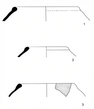
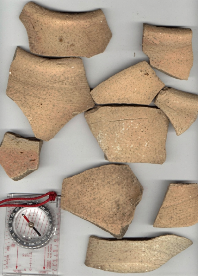
The discovery was surprising, as the site is located in very sandy Breckland soils at a height of 10 metres OD, 2.7 kilometres from the Little Ouse River. Metal detection survey by Ian Hinton produced no finds other than some modern iron — this is a classic example of an archaeological site that can be detected by field-walk methods, but not by metal detection or aerial survey.
Both Andrew Rogerson and Sue Anderson examined the sherds, noting the unusual nature of the fabric and suggesting a potential local production centre, with similar known traditions appearing around Mildenhall and Ely. The sherds are very sharp and fresh looking, suggesting that the site has been undisturbed by modern ploughing.
The fact that the cluster is so dense, and consists entirely of one fabric, could suggest a possible kiln site. However, an alternative is that it represents another specialist use of this site. The modern fen-edge is nearby, as is a known extinct still water. The soil-type is suggestive of wetland. Could these ceramics have been connected to a wetland industry such as eeling?
The Suffolk Historic Environment Record map provides the clear landscape context — the site was situated directly within the boundaries of the expansive Medieval rabbit warren of Brandon (BRD 093), and rests roughly 1 km northeast of the significant monastic site at Wangford Grange (WNG 023). The lava quernstone may represent intensive occupation connected to supplying the monastic economy of the Grange.
The Eel industry in 11th century England A possible link?
Early Medieval Ware
Generally speaking, the fabric or core of the pottery is dark grey, with one or both surfaces a ginger-buff colour, and with a slightly gritty feel. Suffolk Archaeology officially described the fabric as 'of an Early Medieval tradition; with buff-firing, sandy with some calcareous inclusions, generally leached out with occasional flint'. All rims found were of a characteristic inverted profile. My site has been officially recorded onto the Suffolk Historic Environment Record as Monument BRD 152, centred precisely at grid reference ON RECORD.
Waste-Scattered Medieval Ceramics in Thetford Forest
Analysis of medieval ceramics from the collection surveys conducted so far seems to suggest that medieval peasants were more choosy about where they scattered domestic waste than their Romano-British counterparts. I tend to find medieval manure scatter where it should be — on the more drought resistant shallower valley slope soils, rather than the deeper soils of the uplands.
Oteringhythe
Forest-walk 38. Weeting. Norfolk SMR (HER) 35352 TL 79 87 (completed at the close of the 1999/2000 season) took place on a forestry compartment close to the Little Ouse River in Weeting, Norfolk. The survey area is of particular interest because it immediately skirts the edge of the settlement area of the Deserted Medieval Vill (DMV) of Oteringhythe, a settlement recently rediscovered through documentary research carried out by David Dymond.
Much of the survey area evidently formed part of a medieval infield, with broken tiles, including peg-tiles, concentrating heavily along the bottom edge. Processing of the finds reveals that Oteringhythe was considered an attractive place to settle and farm throughout several distinct archaeological periods:
- Prehistoric / Lithic Density: The survey produced the highest lithic density of any of the thirty-eight surveys so far — a Very High Density of 18.1 struck flints per are, including several flint scrapers, flake knives, and hammerstones.
- Iron Age: Evidence of prehistoric settlement extends into the Iron Age, represented by several flint-gritted potsherds collected across the compartment.
- Romano-British: The recovery of Roman ceramics strongly suggests nearby settlement, with recorded finds including both fine Samian tableware and Nene Valley mortaria fragments.