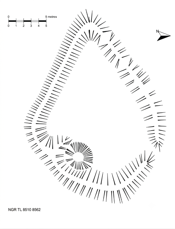
Plan of a Small Enclosure Earthwork
Thetford Forest – Norfolk SMR 33607
This enigmatic earthwork is located within Thetford Warren. I originally discovered and surveyed it during the late 1990s, subsequently reporting the findings to Norfolk Archaeology. The feature was officially recorded as Norfolk SMR 33607 (now maintained within the Norfolk Historic Environment Record).
Regrettably, the site was not sufficiently protected on the ground, and forestry restocking operations in 2000 cut directly across the enclosure, breaching its surrounding banks. The plan indicates a National Grid Reference (NGR) of TL 8510 8562.
Landscape Reassessment & Typology (NHER 33607): In January 2019, this survey was formally re-evaluated by the Breckland National Mapping Programme and the 'Brecks from Above' initiative. While my initial field interpretation in the late 1990s leaned toward a post-medieval sheep compound or pound, modern synthesis of the landscape strongly shifts its function toward the historic, intensive rabbit-warrening industry of Thetford Warren.
The 2015 0.5m airborne LiDAR survey data (Feature #65333) successfully captured the micro-topographical profile of the enclosure, altering the central grid reference slightly north to TL 8508 8587. The internal corner pit I mapped during my fieldwork matches the exact diagnostic criteria for a historic tip trap — a specialised trapping mechanism built directly into warren perimeter banks to manage commercial rabbit yields. Despite the extensive damage caused by forestry restocking operations, the baseline contours of this historic installation remain anchored on the forest floor.
Decades after its initial discovery and subsequent damage, the survival of Norfolk HER 33607 stands as a powerful testament to the value of voluntary field survey in anchoring vulnerable topsoil features into the permanent public record before they are lost to active industrial forestry.