November to December 1997
Forest-Walk 7
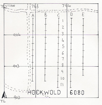
- Forestry Compartment: Hockwold 6080
- Norfolk SMR: n/a
- Parish: Feltwell
- Date: 29/11/97
- Survey Area: 4.08 ha | Sample Fraction: 2.75%
- Centre on: TL 743 903
- Soil: Freckenham / Redlodge complex, upland gravel brown earths and podzol soils
- Relief: Uneven
- Water: 3.4 km to Little Ouse
Finds included:
- 9 unmodified flint flakes.
- 2 burnt flints.
No post-medieval or modern materials found.
Survey Metrics:
- Lithic Sample Size: 9
- Sample Area: 1,122 m²
- Lithic Density: Low (0.8 per are)
- Burnt flint density: 0.18 per are
Forest-Walk 8
- Forestry Compartment: Brandon Park 2001
- Suffolk SMR: BRD 151
- Parish: Brandon
- Date: 13/01/98
- Survey Area: 4.16 ha | Sample Fraction: 2.75%
- Centre on: TL 782 857
- Soil: Freckenham, gravel terrace brown earth
- Relief: West-facing
- Water: 900 metres to Little Ouse | Height OD: 10 to 20 metres
Finds included:
- 1 sherd of Medieval pottery.
- 1 flint plano-convex knife (?Early Bronze Age).
- 2 flint blades (1 micro).
- 20 retouched flint flakes.
- 38 unmodified flint flakes.
- 2 miscellaneous flints, including a probable axehead roughout.
- 5 flint waste cores / fragments.
- 5 burnt flints.
A few sherds of modern brick noted.
This high-density lithic scatter consists mainly of fresh-looking deep black flint, with miscellaneous patches of retouch, sometimes post-patination. The scatter appears to consist mainly of late prehistoric flakes, with a high percentage (30%) of them retouched.
Survey Metrics:
- Lithic Sample Size: 68
- Sample Area: 1,144 m²
- Lithic Density: High (5.94 per are)
- Burnt flint density: 0.44 per are
Forest-Walk 9
- Forestry Compartment: Brandon Park 2003
- Suffolk SMR: BRD 150
- Parish: Brandon
- Date: 18/01/98
- Survey Area: 3.04 ha | Sample Fraction: 2.75%
- Centre on: TL 783 856
- Soil: Worlington / Worlington shallow phase unit, stripy slope brown earths
- Relief: West-facing slope
- Water: 1 km to Little Ouse | Height OD: 10 to 20 metres
This compartment lies directly next to that of forest-walk 8.
Finds included:
- 11 retouched flint flakes.
- 32 unmodified flint flakes.
- 1 miscellaneous flint.
- 5 burnt flints.
No post-medieval or modern materials noted.
Survey Metrics:
- Lithic Sample Size: 44
- Sample Area: 836 m²
- Lithic Density: High (5.26 per are)
- Burnt flint density: 0.6 per are
Forest-Walk 10
- Forestry Compartment: Brandon Park 2033
- Suffolk SMR: BRD misc
- Parish: Brandon
- Date: 13/12/97
- Survey Area: 3.2 ha | Sample Fraction: 3.25%
- Centre on: TL 771 848
- Soil: Brandon / Freckenham complex. Podzolised and gravelly brown earths
- Relief: Flat
- Water: 1.8 km to Little Ouse, 800 metres to extinct fen-edge lake | Height OD: 5 to 10 metres
This forest-walk is located next to the enigmatic 'White Hill' earthwork (BRD 120), and a number of probable post-medieval earthworks.
Finds included:
- 1 flint waste core, possibly post-medieval.
No other post-medieval or modern finds.
Survey Metrics:
- Lithic Sample Size: Nil
- Sample Area: 1,040 m²
- Lithic Density: Very Low (Nil)
- Burnt flint density: Nil
Forest-Walk 11
- Forestry Compartment: Brandon Park 2038
- Suffolk SMR: BRD misc
- Parish: Brandon
- Date: 11/01/98
- Survey Area: 4.4 ha | Sample Fraction: 2.75%
- Centre on: TL 770 845
- Soil: Brandon, Podzol soil
- Relief: Flat
- Water: 1.8 km to Little Ouse, 800 metres to extinct fen-edge lake | Height OD: 5 to 10 metres
An earthbank stretches alongside the southern edge of the compartment.
No finds. No post-medieval or modern material noted.
Survey Metrics:
- Lithic Sample Size: Nil
- Sample Area: 1,210 m²
- Lithic Density: Very Low (Nil)
- Burnt flint density: Nil
Forest-Walk 12
- Forestry Compartment: Brandon Park 2044
- Suffolk SMR: BRD 149
- Parish: Brandon
- Date: 17, 28/12/97
- Survey Area: 3.84 ha | Sample Fraction: 2.75%
- Centre on: TL 774 838
- Soil: Freckenham, a gravelly brown earth at western end, but majority is Methwold / Worlington complex, a semi-calcareous brown earth
- Relief: North-west facing
- Water: 2.7 km to Little Ouse, 1 km to an extinct fen-edge lake | Height OD: 10 to 20 metres
Finds included:
- 1 sherd of ?Romano-British pottery.
- 2 flint scrapers.
- 1 double-sided flint knife/scraper combination.
- 1 flint waste core reutilised as a hammerstone.
- 6 other flint waste cores (1 burnt).
- 6 retouched flint flakes.
- 28 unmodified flint flakes.
- 31 burnt flints.
One sherd of modern brick noted.
Survey Metrics:
- Lithic Sample Size: 44
- Sample Area: 1,056 m²
- Lithic Density: Medium (4.17 per are)
- Burnt flint density: 2.94 per are
Forest-Walk 13
- Forestry Compartment: Elveden 2081
- Suffolk SMR: ELV misc
- Parish: Elveden
- Date: 16/12/97
- Survey Area: 4.72 ha | Sample Fraction: 3.75%
- Centre on: TL 797 819
- Soil: Worlington - deep upland brown earth; also a patch of Santon / Worlington complex, semi-podzolised brown earths, at western end
- Relief: Flat
- Water: 5.2 km to Little Ouse, 3.2 km to Horseshoe Pit | Height OD: 50 metres
The southern edge of the compartment is bordered by a tall earthbank (ELV 036), presumably connected to the warren. There is also a circa 35-metre diameter ?marl pit located alongside the survey area, within the compartment.
Finds included:
- 2 unmodified flint flakes.
- 4 burnt flints.
Background scatter of brick and tile. The presence of the pit, and of the tile and brick fragments scattered across the survey area, would suggest that it formed part of a late post-medieval arable field, prior to afforestation.
Survey Metrics:
- Lithic Sample Size: 2
- Sample Area: 1,770 m²
- Lithic Density: Very Low (0.11 per are)
- Burnt flint density: 0.22 per are