Archaeo-Blog  


Next blog

February 1999 to September 1999

Subsidiary Find 5: Early Medieval Pottery Cluster.
Forestry Compartment Brandon Park 2055.


Suffolk SMR - BRD 152.Parish - Brandon. Date - 27/06/98
Survey Area - 4200 M²
Sample Fraction - reconnaissance
NGR - on record.
Soil - Row: Ground water gley soils.
Relief - flat.
Water - Little Ouse River 2.7 km, but an extinct fenside lake stood c.500 metres to the west.
Height OD - 10 metres.

Ginger jars 12 century

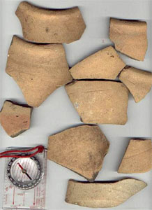
A reconnaissance survey revealed a very dense cluster of sherds all from early medieval pottery; very unusual and of particular interest, because all sherds were of the same fabric and vessel type - mid 11th to late 12th century Early Medieval Ware (EMW) 'Ginger Jars'. The cluster is situated in a forestry compartment that had been clear felled and restocked recently. The cluster spreads over an area of about 70 metres by 60 metres, but could extend further to the south-west under standing pines. The sherds are very sharp, fresh looking and unabraded, with some large fragments. Generally speaking, the fabric or core is dark grey, with one or both surfaces a ginger-buff col­our, and with a slightly gritty feel. Suffolk Archaeology described the sherds as 'of an Early Medieval tradition; with buff-firing, sandy with some calcareous inclusions, generally leached out with occasional flint'. The only decoration consists of a few horizontal grooves. All rims found were of a characteristic inverted profile. Bodysherds suggest a large thin-walled globular shape. Bases were shallow or sagging, and displayed slight oxidisation.

Although the cluster is very dense, no other form of pottery or fabric was found other than EMW ginger jars. The only other artefact found besides prehistoric flints, was a single fragment of larva quern stonee. If this quern is contemporary with the ginger jars, then maybe the cluster represents an unusual early medieval settlement, perhaps with a specialist use that involved the intensive use or production of ginger jars. Andrew Rogerson also ex­amined the sherds, and suggested that they were of an unusual fabric, and that the site could be a production centre. A magnetometer survey of this site could be beneficial.

A sample of the sherds were removed - particularly rimsherds and large fragments, which were taken to Suffolk Archaeology for identification and recording.


Archives

Later Blogs

Previous Blogs

Contact me!

Guest Book

My Portal

Spam and Chips


This page last updated

2005-12-10
(y-m-d)

Paul Brooker

4: Metal Detection at Thetford.
Forestry Compartment High Lodge East 3117


Norfolk SMR - 32785.
Parish - Thetford.
Centre on TL 851 830.
Water - 480 metres from the Little Ouse.

I borrowed a Tesero Laser B1 metal detector during late February 1998, and used it here. I had previously found ample abraded sherds of Medieval and Roman pottery here, but very little saxon evidence. I decided to use the detector here to search for any saxon metal artefacts, not indicated by ceramic evidence.

1 small Cu Late Saxon penannular 'finger' ring. Tapered ends, no decoration.
1 small conical Cu Medieval matrix. The circular die is engraved with a lion rampart, with the legend around SVMLEO FORTIS ('I am a strong lion').
1 decorative mount. In shape of flower. ?late medieval or early post-medieval.

Subsidiary Find 3: Earthwork Mound.
Forestry Compartment High Lodge East 3116.


Norfolk SMR - 33609.
Parish - Thetford.
NGR - TL 8475 8279.

A sub-circular mound, 5 metres diameter, and less than 1 metre in height. I now have reservations that this apparent mound has any archaeological significance.

Subsidiary Find 1: Neolithic Flint Chisel/Axe.
Forestry Compartment Brandon Park 2056

Suffolk SMR - BRD 148.
Parish - Brandon

While I was observing destumping operations here during the late summer, I spotted this artefact underneath an uprooted tree stump. It is a core tool made of light grey patinated flint, of regular shape. It is broken, with a remaining length of 7.2 cm.

Subsidiary Find 2: Fragment of Romano-British Tegula Tile.
Forestry Compartment - on record.


Norfolk SMR - 32349.

This was found during a return visit to this site (see Preparatory Finds, earlier in this report). Previously, only box-flue tiles, and non-descript broken tile fragments had been found. This new find provided stronger evidence of a structure with a tiled roof.
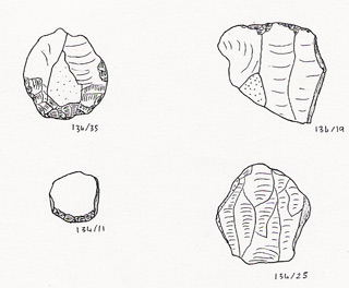
Forest-walk 34
Forestry Compartment High Lodge 2113/2114

Suffolk SMR - WNG 031
Parish - Wangford. Date - 11/09/99
Survey Area - 4.32 ha. Sample Fraction - 2.75 %
Centre on TL 7613 8255 C.
Soil - tba.
Relief - flat.
Water - tba.
Height OD - tba metres OD.

5 sherds of pottery (inc' 2 prehistoric)
1 flint scraper
1 ?oblique flint arrowhead.
8 retouched flint flakes.
72 unmodified flint flakes.
2 flint waste cores
33 burnt flints.

A little slate, tile and brick fragment found.

Fifty four stints were walked across this destumped compartment on the 11th September 1999. The viewing width was set at 110 cm.

Lithic Sample Size = 84. Sample Area = 1188 M²
Lithic Density for Forest-walk 34 = 7.07 per are² > High Density. Burnt flint density = 2.78 per are²

This compartment lays close to the fen-edge area of Lakenheath Airfield. Two sherds of ?bronze age pottery were found close together at TL 7616 8255 A. A slight cluster of burnt flints was found at TL 7603 8257 A. The level of retouch on flakes was very low, although many had subtle signs of possible utilisation.

Re-utilisation shows at least two phases present, though the earlier (patinated mainly) industry is thin. Later industry generally squat and very poor quality. Also very high amount of cortxual flint (80%) and relatively high hinge fracture count (note high cortex depresses this potential figure) (note excludes cores) of 19%; together with large number of notched flakes (cf Ford etal) lead to conclusion that main industry is of the later bronze age. - Colin Pendleton Suffolk CC.

Forest-walk 33
Forestry Compartment Kings 4149


Suffolk SMR -WRW025.
Parish - Wordwell. Date - 25/02/99.
Survey Area - 3.2 ha. Sample Fraction - 2.75 %
Centre on TL 8362 7540.
Soil - Methwold/Worlington/Worlington (stripy unit) - lower grade slope brownearths, with a splash of Worlington, true upland brown earth at northern end.
Relief - south-facing slope.
Water - River Lark 5 km; Rymer ponds 3.2 km.
Height OD - 50 metres.

2 retouched flint flakes.
26 flint flakes.
4 burnt flints.

Flakes were concentrated on the northern side of the survey area. No post-medieval or modern ceramics were found.

Flint mostly with varied amounts of blotchy grey patination. Mostly squat and with cortex. Poor quality assemblage - ?Late prehistoric. - Colin Pendleton, Suffolk C.C.

Lithic Sample Size = 28. Sample Area = 880 M²
Medium Lithic Density for Forest-walk 33 = 3.18 per are². Burnt flint density = 0.45 per are²

worked flint flakes

Forest-walk 32.
Forestry Compartment Roudham 2045

Norfolk SMR - 34184
Parish - Roudham. Date - 14/02/99.
Survey Area - 2.94 ha. Sample Fraction - 11 %
Centre on TL 9480 8692
Soil - Methwold/Worlington - partly calcareous slope brown earths.
Relief - flat
Water - Little Ouse River 1.7 km; stream at Roudham DMV 600 metres.
Height OD - 25 to 30 metres.
Transects were spaced at 10 metres distance apart.

A few sherds of pottery, including one of Middle Saxon date, were collected here during an earthwork survey by Brian Cushion for the Forestry Commission. It was felt that the com­partment deserved a closer look.

1 sherd of ?Romano-British grey ware pottery
9 sherds of Medieval pottery (1 glazed, 8 unglazed).
2 sherds of Late Medieval / Early Post-medieval pottery.
1 crude flint scraper.BR>1 'nosed' flint scraper.
2 retouched flint flakes.
28 flint flakes.
147 burnt flints.

Background scatter of Post-medieval / Modern tile and brick fragments.

Although surrounded by the humps, hollows, and bars that are typical of gravel uplands and terraces in Breckland, the surveyed area is quite flat, and the soil is calcareous enough to deserve destumping. The light scatters of ceramics and rubbish from different periods suggests that the surveyed area has been cultivated and manured with domestic waste on a number of occasions. Corbett's soil map shows the surveyed area consists of partly calcareous brown earths, while the surrounding compartments contain deeper upland brown earth. This would appear to explain why the surveyed area is flat and contains manure scatter, while the surfaces of surrounding compartments are uneven.

Main raw material is weathered nodules of blackish flint (Grimes Graves type), with a few pebbles. Some flakes very sharp. Probably late prehistoric. High level of burnt flint noteworthy. - notes by Peter Robins for Norfolk Museum Services.

Lithic Sample Size = 32. Sample Area = 3234 M²
Low Lithic Density for Forest-walk 32 = 0.99 per are². Burnt flint density = 4.55 per are²


Previous blog