September 1999 to January 2000
Visit to the Norfolk Archaeological Unit
Roman ceramic finds from site 32349 were compared with material from Two Mile Bottom at the NAU. No matches for the decorated white wares found in the kilns were identified in my collection.
Report - February 2000
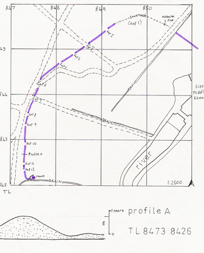
Subsidiary Find 9: Linear Earthwork
Forestry Compartment Downham 5057
- Norfolk SMR: tba | Parish: Thetford | NGR: TL 8439 8449
A slight linear bank, under 50 cm high and 110 metres long, situated in Thetford Warren. It was surveyed on 23/06/1998 but has since been destroyed by restocking operations.
8: Prehistoric Pottery in Thetford Warren
Forestry Comp Downham 5040
- Norfolk SMR: 32344 | Parish: Thetford | Centre on: TL 848 847
Reconnaissance in September 1998 yielded prehistoric Bronze Age, Roman, and Medieval pottery. Flint finds from 1995 and the new assemblage suggest Neolithic interest and potential Mesolithic activity.
Subsidiary Find 7: 19th Century Bank and Mesolithic Microlith
Forestry Comp Downham 5040
Survey of a 700-metre woodland boundary bank dating to the 19th century. A Late Mesolithic microlith was recovered from a sand-mark where the bank had been damaged.
"Microlith: Obliquely blunted with ancillary RHS dorsal retouch... Mesolithic (probably Later Meso)" — Peter Robins.
Forest-walk 37
Forestry Compartment Santon Warren 3083
- Norfolk SMR: ?5655 | Date: 22-23/01/2000 | Lithic Density: 7.49 per are
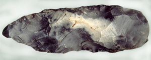
74 stints were walked; findings included a flint axehead, a plano-convex knife, and various flakes. The low flake utilisation suggests primary knapping activity.