Looking at the Wayback Machine snapshots, it appears that the cluster of micro-sites, hosted under the domain spamandchips.net, went offline sometime shortly after September 2009. I hadn't maintained them for a few years.
Here I am in 2026, still regretting the loss, caused by my failure to keep up with server costs. However, for many years I was aware that incomplete snapshots had been taken and saved on web.archive.com. Encouraged and guided by AI, I have now restored my micro-sites back to live status on netlify.
Collecting v Archaeology
Archaeology is terribly political – and I have had my own fingers burnt on more than one occasion. Here in the UK, the debate mainly centres around metal detecting – a hobby that is legal here. Some archaeologists accept it, but many hate it. To try and resolve the conflict, the UK Government introduced the Portable Antiquities Scheme, which encourages metal detectorists to record their removed finds.
Supporters of the scheme claim that it has enabled the recording of thousands of removed artefacts that otherwise would have been lost to the record, and that this record provides archaeological data that can be processed to help us understand the past. Opponents hold a more conservative view – they would like to see metal detecting and artefact collecting illegalised – they see it as a plunder of Britain's heritage by collectors and dealers. I am not going to take sides here – as I said, I have had my fingers burnt before. But I would like to give an example of my experience.
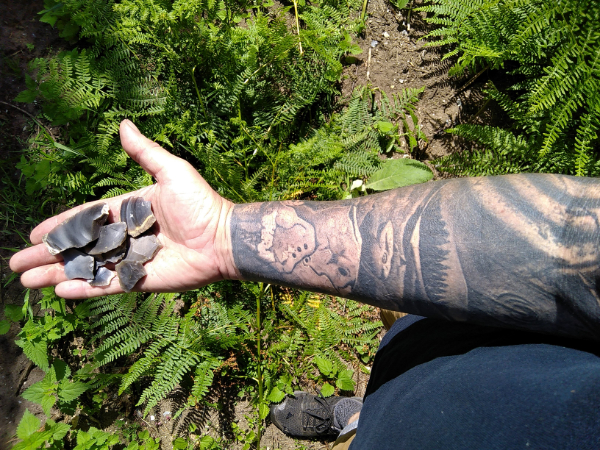
I stumbled into flint collecting by accident – a chance discovery, a few old guidebooks, and inspired by old literature, I started searching for flint implements. Why was I doing it? Fascination with picking up something deposited thousands of years ago – the excitement of discovery. I also thought that I was contributing to the archaeological record – I faithfully presented each scraper or arrowhead to the local museum, and later to local government archaeologists, who recorded it all onto the SMR (Sites and Monuments Record).
Then I studied field archaeology and landscape history on a part-time, two-year night-school course – and I became acutely aware that I could do a lot more to produce a meaningful record. I improved my techniques and developed my own system of field-walking that produced a representative sample rather than a collection of pretty finds. I also loved computers, and I wanted to produce my own crunchable data – that would map find distributions across the forest – their densities and their characteristics.
So, following my five-year break, how do I feel about the ethics of collection now? I am more acutely aware that archaeology is about using evidence to understand the past. I feel that we all too easily forget that – and become find-centric. I wish that I could write a book on the prehistory of my area, based on my finds – but could I? It is easy for me to become obsessed about find characteristics, hinge fractures, flake types, and densities of burnt flints – but how is that helping me tell a story of the past? Am I simply satisfying my innate collecting instincts, or am I producing worthwhile information? This is something that I am going to need to consider more in the future.
Books, Books, Books
Books that I have recently read and enjoyed as part of my return to field-walking:
Britain BC: Life in Britain and Ireland Before the Romans. Francis Pryor, 2004.
Britain AD: A Quest for Arthur, England and the Anglo-Saxons. Francis Pryor, 2005.
Stone Tools and Society: Working Stone in Neolithic and Bronze Age Britain. Mark Edmonds, 1995.
I also flicked through/reread Bronze Age Britain by Michael Parker Pearson (1993), and I have just started reading Prehistoric Flintwork by Chris Butler (2005). I have also bought Stone Age Archaeology: Essays in Honour of John Wymer by Nick Ashton et al., 1998.
Some of this reading after my long break has been really refreshing – it has changed the way that I used to see much of British prehistory – and early English history for that matter. Some old views really were rather boring and improbable – Neolithic invaders from the Middle East, Windmill Hill A people, Windmill Hill B people, Beaker people, Hallstatt Celtic, La Tène Celtic, Belgic Celtic... invasion after invasion, yawn. I remember an old Welsh headmaster telling us that we East Anglian kids were all invaders, and that true Brits like him had been forced into Wales. I mean, think about it – Late Roman lowland Britain – thriving, high population – lots of trade to the near continent. We were expected to believe that some bands of Germanic Iron Age tribespeople came over in little boats – and in less than a century, wiped out most of the population of south-east Britain, and squeezed the survivors westwards into little Wales. Funny how archaeologists haven't found any of the mass graves. The Anglo-Saxons must have been pretty invincible – heavily outnumbered, with nothing more than swords and bad breath, they allegedly slaughtered the old Brits – then cremated and crushed their bones to powder so that we couldn't find any evidence of this genocide. Those Romano-Brits must have been real wimps! Problem is – we all sucked it in – and it is still the established view. It really has made me think about origin myths, and cultural, national, and ethnic identity.
I Want!
I want, I really want, one of these resistivity meters. A shade maybe under £1,000 – could someone buy me one? My wife tells me that she would let me buy one maybe later this year (although she thinks that a new laptop would be a better idea). Does anyone out there have experience with TR System resistivity meters? Geophysical surveying really is attractive – no more invasion of artefacts or sites – and I bet that there are tonnes of places just aching for an amateur autologging resistivity survey. Do you have experience of TR System autologging resistivity meters? Are there any professional field archaeologists reading this that can advise me? Is there a need for amateur resistivity surveying? Please email me your thoughts – I need help... thanks.
New Survey Models Next Field-Walking Season?
I am seriously considering radically changing the format of field-walking survey that I employ in the Forest next winter.
1. Surveying by GPS alone!
The first change that I am considering is purely a result of improved technology. I have always plotted out surveys onto hand-drawn 1:2500 map plans based on larger OS maps. Grid references were deduced by measuring from a known reference point by tape measure – then stints were tracked by measurements taken during surveys by pushing a measuring wheel as I searched. Transect spacing was measured by wheel or by tape measure. The result wasn't perfect – but for quick, single-handed surveys, it was reasonably good quality. All removed finds were marked to a stint, which was accompanied by an approximate eight-figure grid reference – much better than most of the grid surveys carried out by archaeology schools and societies. It was a method that I was quite proud of.
However, I have been experimenting with a handheld, WAAS-enabled GPS receiver – and I am so impressed by its accuracy and reliability (see the GPS tracking of Survey 39 to the right), that I am considering ditching the wheel and tape in favour of recording GPS track and waypoint data – and building survey plans on that instead. I may use the GPS to measure out both transect spacing – and the stints themselves. Accuracy of non-differential handheld GPS is often criticised, but I feel that trials so far show the GPS to be more accurate than dodging around compartments single-handed with measuring tapes and a wheel, and perfectly within the parameters of a linear surface collection sampling survey. It would also enable me to make the next crucial reform to my method detailed below.
2. Artefact Recording Survey – with Minimal Removal
Since I resumed the Thetford Forest Archaeology Project, I have been bothered by my conscience – should I be removing archaeological finds from the surface – could I not simply record them, and leave them there? Finds are not at risk in the forest – with the exception of frail ceramics, there is little risk to small finds from forestry operations. Although my surveys only remove circa 3% of finds from any of the survey areas – I feel that I am invading what I should be helping to conserve.
The surveys that I have carried out in January 2006 produced volumes of flint finds – many of them waste flakes and lithic debris. I do like to record them all, so that I can, for example, compare finds such as flakes with utilisation, or with notches, or hinge fractures – the amount of blade-like flakes, etc. I believe that enough of this type of data can help me produce a more detailed picture of prehistoric flake scatters across Breckland, along with their characteristics and origins – but do I have to remove them in order to record that data?
I am considering trialling some surveys next winter – where I remove no finds except ceramics. I already only record burnt flints (potboilers) and do not remove them – how about treating all lithic finds the same way? I could maybe create forms to be filled out in the field – recording things like hinge fractures, utilisation, etc. Formalised flint tools could be digitally photographed in the field – rather than removing them. I would still need to remove potsherds, as I find them much harder to identify. Surveys in the field would take much longer to conduct – in limited winter daylight – but surveying by GPS would save some of that time. It will, though, save lots of finds processing time – both the cleaning, examining, labelling, and bagging by myself – and the time of paid SMR/Finds officers and staff.
Would SMR officers accept recorded finds and digital images instead of the removed finds themselves? How do they feel about this? I cannot think of a more ethical way of surveying – minimalising damage to the topsoil archaeology. What do you think? Please, I would welcome more views.
New Surveys!
Forestry Enterprise have granted me a new permit to field-walk survey, following my long break. I have been on holiday this week, so I have been cracking on with fieldwork – and have completed three surveys already! Finds will be processed within the coming weeks, but here is a summary of what I have found so far.
Forestwalk survey 39 took place at Santon Belt – not too far from the Bloodhill round barrow. Lithic density looks quite high, and was quite interesting. Flint finds included a broken segment of a Neolithic polished flint axehead. This is actually the first time that I have found one in the Forest! Three informal scrapers and a piercer were also recorded. Particularly interesting, I recorded several blade-like flakes, including the retouched example to the left that looks distinctly Mesolithic rather than later! Ceramic finds consisted of two abraded potsherds that look Roman.
Forestwalk surveys 40 and 41 both took place in Santon Warren, crucially between the Grime's Graves Neolithic flint mine site and the Little Ouse River, on south-facing valley slopes. Survey 40 was lower down the slopes near to a known riverside Romano-British settlement, while Survey 41 was higher up the slopes above it. Survey 40 was not very productive – no ceramics, and a medium-looking density of flint finds. However, the soil was very sandy, which could suggest that some finds are buried under sand-blow. The top end of Survey 41 further up the slopes had a much higher density of struck flints. Flakes there were typically large, fresh-looking, dark, and unretouched. I did not see any tools in the collection nor blades – just big chunky waste flint and lots of it. I did find hammerstones – they don't often turn up like this. This wasn't a living area, but an area where flint has been processed into blanks or maybe cores. It is tempting to suggest that Grime's Graves flint (or local outcrops) was being knocked down to size here on its way down to the river.
Google Earth Plus and Garmin Etrex GPS
I can get Google Earth Plus to see my Garmin on the serial link now – I simply have to wait a few minutes to download waypoints and tracks. It is a nice toy, and may be worth the money to see where you have walked from above. However, it's not particularly pretty or useful in the low-definition zones (e.g., Thetford Warren), but is great to look at in the higher-definition zones (including Kings Forest at this time). I found a British National Grid Overlay in the Google Earth Community that draws the British Grid over viewed areas – nice, but the author admits that it is not perfectly drawn, and the grid only draws down to 1 km squares (four numbers).
My main criticism of Google Earth Plus is that accuracy seems to leave a certain amount to be desired – or at least it doesn't strictly agree with the GPS. Still, a very nice toy, and maybe worth the USD $20 per year subscription – particularly for examining tracks after walks into high-definition zones. You can see a screendump image of a walk in Kings Forest to a barrow to the right.
For more serious plotting, though, I still prefer the GarTrip program, that allows you to easily and quickly set waypoints onto the Garmin Etrex. You can use scanned maps and calibrate them, creating larger high-resolution digital maps.
By the way, I visited the Grime's Graves round barrows – photographs and grid references can be found in the Earthworks Gallery.
GPS Software
Having now received delivery of a PC patch serial link lead, I have been looking at software suitable for using with my new Garmin Etrex handheld GPS receiver. It's a little early to review any, but here is what I have found and tried so far (prices and conditions at time of posting this blog):
GarTrip: Price: shareware version free for testing (no time limit) but restricted to 30 waypoints, one route, and 500 track points. Registered version price was EUR 30 or USD $35. It includes British (OS) National Grid Referencing.
Expert GPS: Price: USD $59.95 for single licence personal use. Shareware version is restricted to only a 30 days trial. Comes with some US maps and flyover photomaps, but not UK. However, British (OS) National Grid Referencing is included.
Google Earth Plus: The free version of Google Earth is very popular and well worth having. However, GPS compatibility is offered on the Google Earth Plus version for a subscription of USD $20 per year. So far, I have been unable to make Google Earth Plus see my Garmin Etrex on the serial link – but I will have to fiddle with configs before I declare this program to be u/s and incompatible for the Etrex. It doesn't appear to support British (OS) National Grid Referencing though. Disappointing so far.
EasyGPS: Price: free – cut down version of ExpertGPS. It seems popular, but what has choked me off initially is the apparent absence of British (OS) National Grid Referencing. This is available on the above ExpertGPS product, but at a price.
My initial response is in favour of the GarTrip product. Although it has a shareware version, I have decided to register this software. At first, GarTrip looks very basic, but browsing through the Help contents reveals a deeper content. I am presently building maps of the forest areas, using the OS online Get-a-map service and some photoshopping. GarTrip allows me to calibrate these maps so that I can plot waypoints and routes in advance on high-quality 1:25,000 maps (plus zooming), examine waypoints and tracks uploaded from the Garmin, add information to the waypoints, etc. It will hopefully also allow me to accurately plot and print survey plans themselves.
While compiling and calibrating maps for GarTrip, I had a look at the tumuli mapped in the Grime's Graves area. I had to make a trip to Brandon today, and on the way back, made a detour to try using the Garmin to navigate to a pair of them. Consequently, I found two round barrows that I hadn't seen before – I will try to photograph them in the next few days.