October 1998 to November 1998
Forest-Walk 20
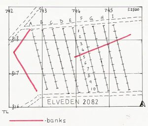
- Forestry Compartment: Elveden 2082
- Suffolk SMR: ELV Misc.
- Parish: Elveden
- Date: 01/10/98
- Survey Area: 5.28 ha | Sample Fraction: 3.33%
- Centre on: TL 7941 8174
- Soil: Santon/Worlington (north), Worlington (south)
- Relief: Flat upland
- Water: 5 km to Little Ouse | Height OD: 50 metres
Transects were spaced at 30 metres distance apart.
Finds included:
- 3 sherds of undated pottery.
- 10 flint flakes.
- 1 burnt flint.
A previously unrecorded, low-lying and poorly defined bank was detected within the surveyed area, stretching from TL 7939 8175 to TL 7956 8181. No post-medieval or modern artefacts were found to the north of the bank, but there were scatters of broken tile, brick, and a few modern potsherds to the south of it; indicating that this earthwork represents a field-boundary, used during the Late Post-Medieval and possibly earlier.
Survey Metrics:
- Lithic Sample Size: 10
- Sample Area: 1,760 m²
- Lithic Density: Low (0.57 per are)
- Burnt flint density: 0.06 per are
Forest-Walk 21
- Forestry Compartment: Didlington Highash 2012
- Norfolk SMR: 34052
- Parish: Foulden
- Date: 18/10/98
- Survey Area: 4.74 ha | Sample Fraction: 3.33%
- Centre on: TL 7863 9939
- Soil: Methwold/Newmarket (NE side), Methwold/Worlington (SE side)
- Relief: Slight west-facing slope
- Water: Stream 1.5 km NW | Height OD: 15-20 metres
Transects were spaced at 30 metres distance apart.
Finds included:
- 4 sherds of Medieval pottery.
- 1 flint scraper.
- 1 unfinished or broken flint arrowhead.
- 13 retouched flint flakes.
- 41 unmodified flint flakes.
- 2 flint waste cores.
- 1 burnt flint.
The sherds of medieval pottery suggest that this area was cultivated during the Middle Ages. A background scatter of post-medieval or modern tile and brick shards lies across the surveyed area; and a pit — probably from marl extraction, is located at TL 7853 9952. This indicates that this area of the forest was also cultivated in recent centuries.
Survey Metrics:
- Lithic Sample Size: 58
- Sample Area: 1,580 m²
- Lithic Density: Medium (3.8 per are)
- Burnt flint density: 0.06 per are
Forest-Walk 22

- Forestry Compartment: Didlington Highash 2022
- Norfolk SMR: 34164
- Parish: Foulden and Didlington
- Date: 25/10/98
- Survey Area: 3.66 ha | Sample Fraction: 3%
- Centre on: TL 7941 9835
- Soil: Methwold/Worlington slope brown earths
- Relief: Slight south-west facing slope
- Water: 2.7 km from River Wissey
Transects were spaced at 30 metres distance apart.
Finds included:
- 1 sherd of Medieval pottery.
- 6 retouched flint flakes.
- 21 flint flakes.
- 3 small waste cores.
- 1 burnt flint.
No post-medieval or modern finds.
Survey Metrics:
- Lithic Sample Size: 30
- Sample Area: 1,098 m²
- Lithic Density: Medium (2.73 per are)
- Burnt flint density: 0.09 per are
Forest-Walk 23
- Forestry Compartment: Hockwold 6096
- Norfolk SMR: 34167
- Parish: Hockwold-cum-Wilton
- Date: 01/11/98
- Survey Area: 2.88 ha | Sample Fraction: 2.75%
- Centre on: TL 7516 8907
- Soil: Freckenham/Red Lodge gravelly upland
- Relief: Uneven upland
- Water: 2.1 km to Little Ouse
Part of the compartment has been designated as site 32593 and has not been restocked. Within this conservation area lies a disturbed mound.
Finds included:
- 1 flint 'button' scraper (probably Early Bronze Age).
- 5 flint flakes.
- 1 burnt flint.
- 1 brick sherd.
Survey Metrics:
- Lithic Sample Size: 6
- Sample Area: 792 m²
- Lithic Density: Low (0.76 per are)
- Burnt flint density: 0.13 per are